
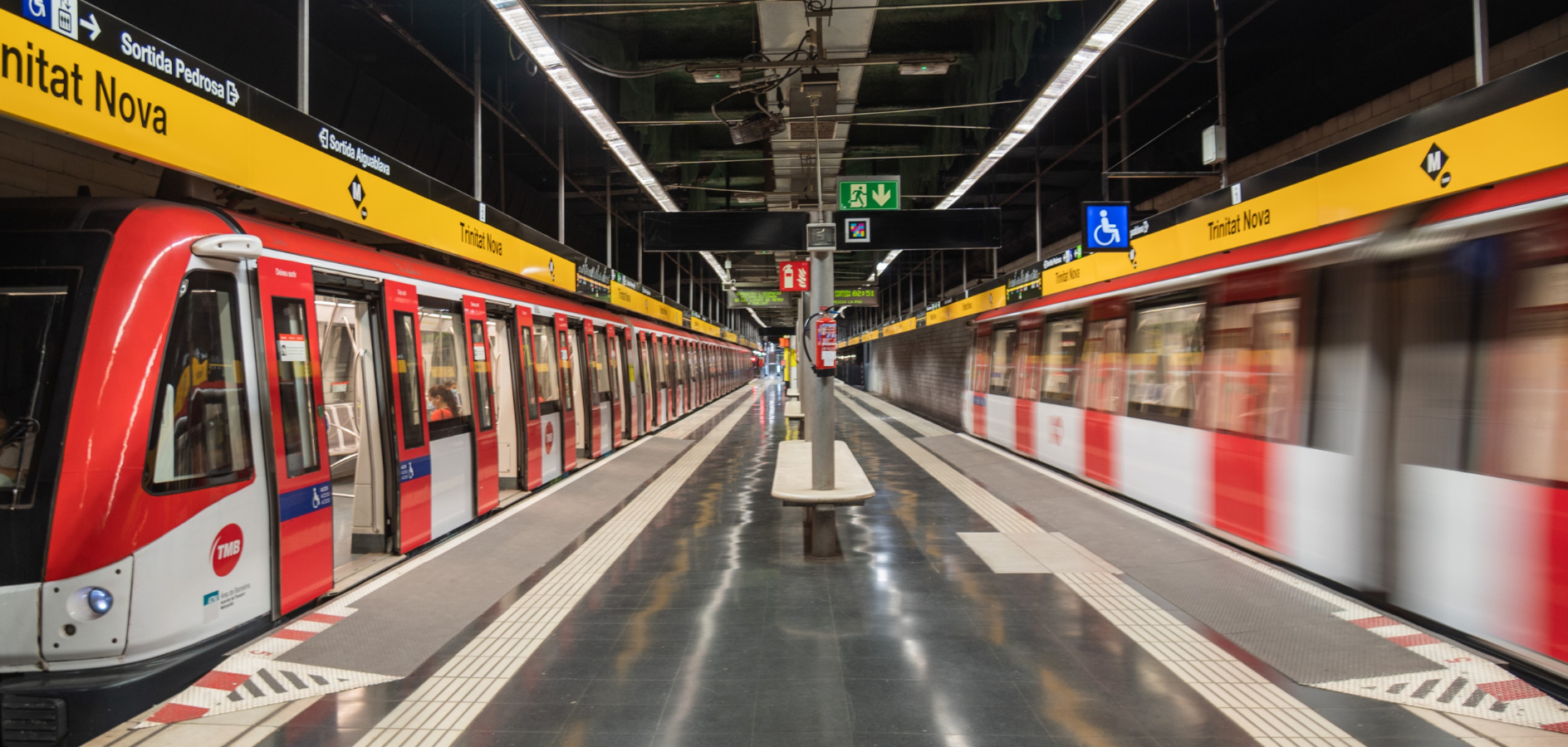
Barcelona is one of the cities with the most extensive metro network in Spain, second only to Madrid. It has 11 lines, 165 stations and 125.4 km of underground tracks, covering a large part of the city.
It is a network of lines and stations so developed and well connected that navigating it is relatively easy. This allows the metro network to reach other municipalities that you may also be interested in visiting: Badalona, Cornellà de Llobregat, Esplugues de Llobregat, L’Hospitalet de Llobregat, Montcada i Reixac, Sant Adrià del Besòs, Sant Boi de Llobregat, Santa Coloma de Gramenet and El Prat de Llobregat which is where we are, the Alberg Centre Esplai!
Since you probably won’t only use the metro, we’ve prepared a complete guide to Barcelona’s public transport, so you can choose the means of transport that’s most useful for you to get around!
Barcelona Metro map and lines

Download the map in PDF so that it is more comfortable for you and you have a clearer vision of the Barcelona metro network.
Line L1: Hospital de Bellvitge - Fondo
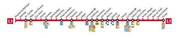
This metro line is the second oldest in the existing network in Barcelona. It arose from the need to unite several stations that formerly operated with the railway system. In fact, it is a line that unites 4 different municipalities: Hospitalet de Llobregat, Barcelona, Santa Coloma de Gramenet and Badalona. The best known stations and where you will have to get off to visit the most emblematic places in Barcelona are Arc de Triomf, Catalunya, Universitat and Espanya.
Of the 30 stations on this line, 26 are adapted for people with reduced mobility and 3 are not (Plaça de Sants, Espanya and Urquinaona). At the Clot stop, the L1-L2 link is not adapted.
Line L2: Paral·lel - Badalona Pompeu Fabra
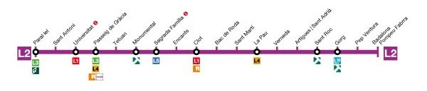
This is the line represented by the color purple. It also connects several municipalities such as Barcelona, Sant Adrià del Besòs and Badalona. And if you take this line you will have to visit one of the most important monuments in Barcelona and designed by Antoni Gaudí: the Sagrada Família!
Of the 18 stations on this line, all are adapted for people with reduced mobility. It should be noted that the L1-L2 link at the Clot stop is not adapted.
Line L3: Zona Universitària - Trinitat Nova
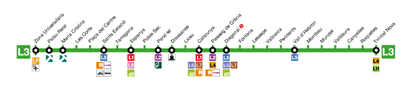
Line 3 (or green line) of Barcelona is the oldest in the city. It was inaugurated in 1924, but it did not debut with the number of stations that there are now, but rather they made a first section between Catalunya and Lesseps. This line crosses Barcelona from Les Corts to Nou Barris, passing through Sants, Ciutat Vella, l’Eixample and Gràcia.
Of the 26 stations on this line, all are adapted for people with reduced mobility.
Line L4: La Pau - Trinitat Nova
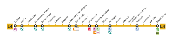
The yellow line or L4 of the Barcelona metro covers a fairly large area that includes the neighborhoods of Ciutat Vella, Eixample, Gràcia, Horta-Guinardó, Nou Barris and Sant Martí.
Of the 22 stations on this line, 20 are adapted for people with reduced mobility and 2 are not (Verdaguer and Urquinaona).
Line L5: Cornellà Centre - Vall d'Hebron
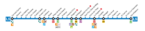
The blue line or L5 covers the municipalities of Cornellà de Llobregat, l’Hospitalet de Llobregat, Esplugues de Llobregat and Barcelona.
Of the 27 stations on this line, 23 are adapted for people with reduced mobility and 4 are not (Virrei Amat, Plaça de Sants, Verdaguer and Maragall).
Line L9 Nord: La Sagrera - Can Zam
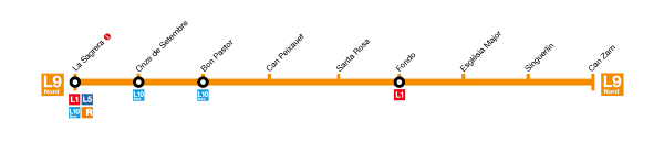
The L9 Nord line, together with the L9 Sud and the L10, are the newest and most automated lines on the Barcelona rail network. Specifically, the L9 Sud opened in 2009 and was the first time that the city of Barcelona saw driverless and automated metro cars.
As it is one of the newest lines, all the stations that are part of it are adapted for people with reduced mobility.
Line L9 Sud: Aeroport T1 - Zona Universitària
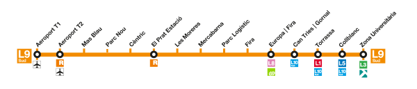
This is our favorite line on the Barcelona metro network!
This is the line that will allow you to come to Alberg Centre Esplai (Parc Nou stop) to have a good stay. We are lucky to be located on one of the most convenient lines, since we have the airport very close and other stations that connect with other metro lines such as the L10, L1, L5 and L3, the Renfe Rodalies at the Prat de Llobregat station and the Ferrocarrils de la Generalitat de Catalunya at the Europa | Fira station.
It is one of the newest lines, like the L9 Nord, and all the stations that are part of it are adapted for people with reduced mobility.
Line L10 Nord: La Sagrera - Gorg

As you can see, the L10 line shares attributes with the L9: there are two different sections, the North section and the South section. The idea is to connect and complete the lines so that they become just one.
All stations that are part of the L10 line are adapted for people with reduced mobility.
Line L10 Sud: Foc - Collblanc
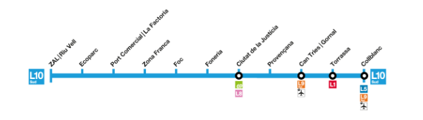
The L10 Sud metro line is made up of 11 stations located in various areas of Hospitalet de Llobregat. As we have said before, the objective in the coming years will be to join this section with the North section to create a line that crosses the whole of Barcelona until reaching the municipality of Sant Adrià del Bessòs.
As part of the new metro lines, all stations are adapted for people with reduced mobility.
Line L11: Trinitat Nova - Can Cuiàs

Line L11 is one of the shortest lines in the Barcelona metro network. In fact, this line was created due to the need to connect Nou Barris of Barcelona with the municipality of Montcada i Reixac. Along with L9 and L10, it is a fully automated line.
All stations that are part of the L11 line are adapted for people with reduced mobility.
Funicular of Montjuïc: Paral·lel - Parc de Montjuïc
In addition to the 10 metro lines that are part of the Barcelona railway network, there is also the Montjuïc Funicular. This is a very fast means of transport that in 2 minutes, transports you from the city center to the mountain of Montjuïc. And great for spending an afternoon with the wonderful views it offers!
The use of the Montjuïc Funicular is suitable for people with reduced mobility.
Tickets and Fares
This ticket is only valid for a single trip.
€2.90
This ticket has a total of 10 trips. It is most useful if you have to spend a few days in Barcelona.
€13.00
This ticket allows you to travel unlimitedly from the start of the day until the end.
€12’00
This ticket is multi-personal and allows you to make 8 trips in 30 consecutive days from the first validation.
€11.50
The Hola Barcelona Travel Card is a single-person ticket that allows you to travel using all types of public transport without limits. If you buy it online, you can enjoy a 10% discount. There are several types:
2 days €18.70
3 days €27.30
4 days €35.60
5 days €43.60
The Barcelona Card is a ticket very similar to the previous one, the Hola Barcelona Travel Card, but it is complemented by discounts on various tourist attractions. Since the pricing system varies a lot, we provide you with its website where you can see all the information.
TMB App
The Barcelona Metropolitan Transport application (Android and IOS) offers a more comfortable, efficient and sustainable mobility experience. It allows you to consult all the information related to public transport and cycling, as well as plan your trips around Barcelona and its metropolitan area in a simple and quick way.
Through the app, you can find out the status of metro and bus lines and stops, check waiting times in real time and locate the nearest stops and stations. It also includes reading ddTag codes to access information, such as schedules and notices, as well as a complete route finder. Everything you need to get around the city, in a single app!

We can say that this means of transport is one of the most used in the Barcelona area. In fact, in 2024 the record for passengers was broken: 684 million validations were made throughout the year. We encourage you to increase this figure to make Barcelona a much more sustainable province!
And in addition to committing to sustainability when using this means of transport, it also saves economic value and time, which we can use to do other activities while we use it: reading, listening to music or even interacting with the people around us!
And to make your journeys easier, we encourage you to visit the TMB website. There you will find all the information you need, including a very useful tool for planning your itineraries and knowing exactly which metro you should take at any given time!